


In the heart of the Desert Uplands, Moorrinya National Park protects 18 land types in the Lake Eyre Basin, one of Australia’s most important water catchments. This remote park has dry, flat plains criss-crossed by watercourses and covered in open eucalypt, paperbark and acacia woodlands and grasslands. Camping is available in a remote and undeveloped setting.
Getting there
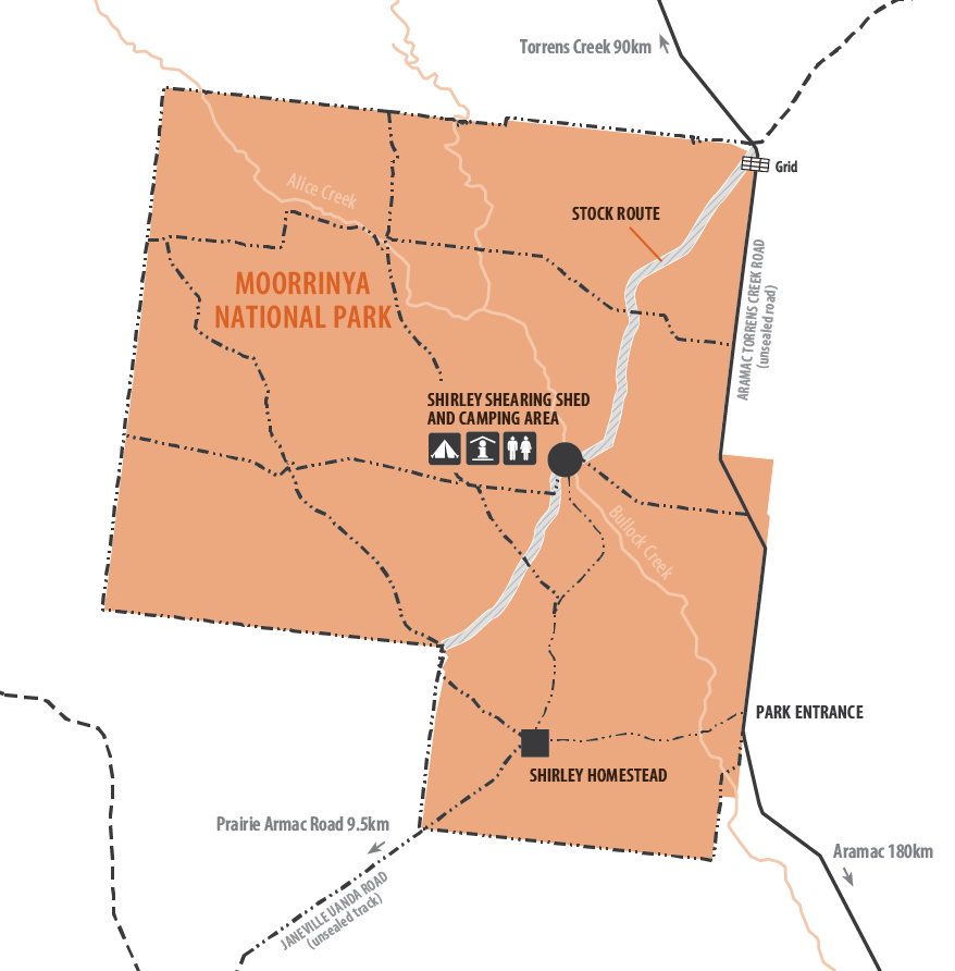
The park turnoff is approximately 106km north-east of
From Townsville, travel south-west for 296km to Torrens Creek on the Flinders Highway. Moorrinya National Park is about 90km south of Torrens Creek on the Aramac Torrens Creek Road. If travelling from the south, the park is 180km north of Aramac, on the Aramac Torrens Creek Road. A directional sign marks the entrance to the park.
Access to the Shirley Shearing Shed camping area is marked by directional signs. From the entrance on the Aramac Torrens Creek Road, the track crosses Bullock Creek and travels for 6.5km through acacia and bluegrass communities. Turn right, just past the Shirley Homestead and travel 4.5km to a Y intersection. The camping area is 4.3km along the right-hand side road.
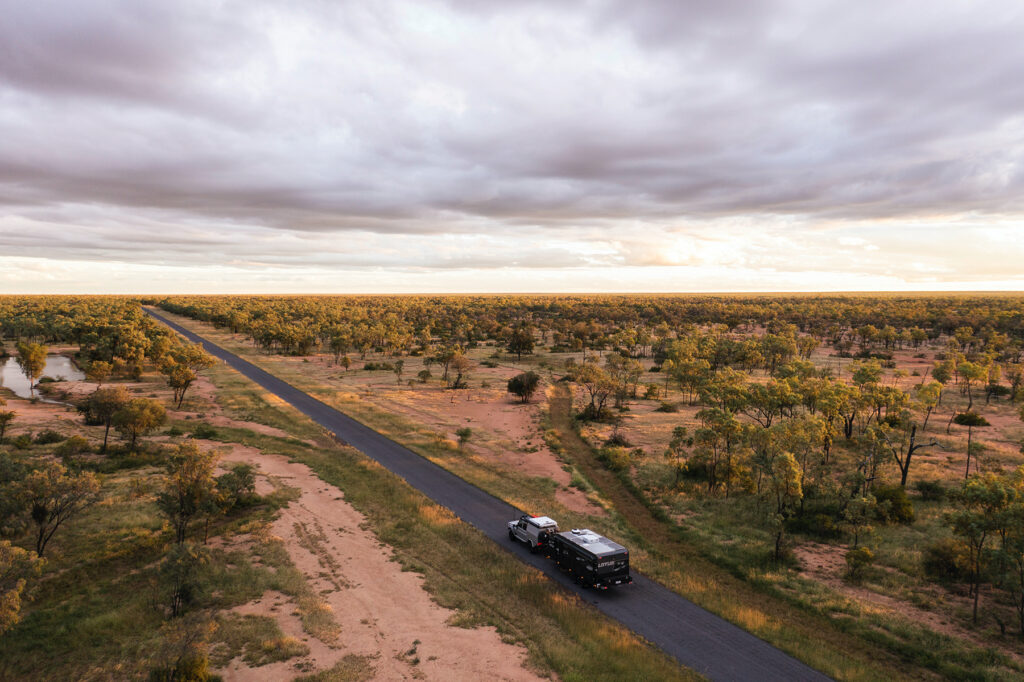
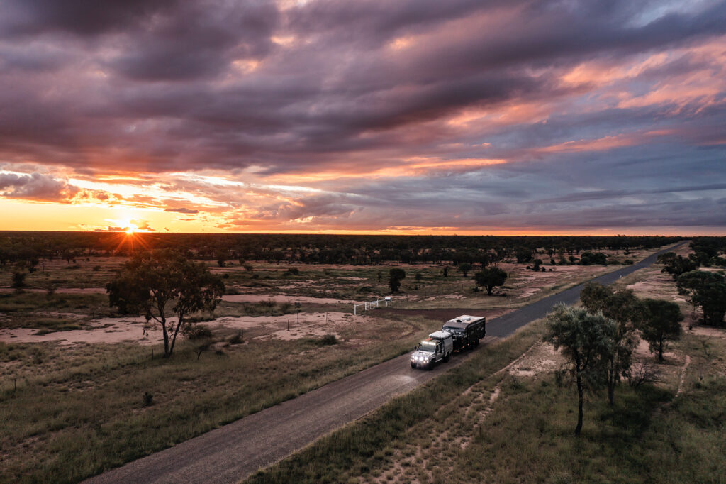
Four-wheel-drive vehicles are recommended to access the camping area as the tracks are rough and become impassable to conventional vehicles after rain. Vehicle access is not maintained within the stock route. The park may be closed during the wet season (November to April). Check with the Department of Transport and Main Roads for road conditions and the Bureau of Meteorology for local weather information.
Park features
Moorrinya National Park protects 32,607 ha and is located in the heart of the Desert Uplands, protecting 18 vegetation communities in the Lake Eyre Basin, one of Australia’s most important catchments.
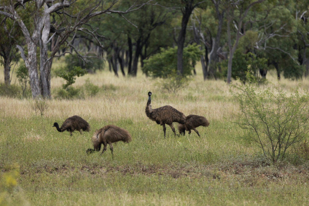
This remote park has dry, flat plains criss-crossed by watercourses and covered in open eucalypt, paperbark and acacia woodlands and grasslands. Moorrinya is a wildlife refuge, protecting Australian icons such as kangaroos, koalas, emus and dingoes, as well as threatened species such as the square-tailed kite, squatter pigeon (southern subspecies) and the Julia Creek Dunnart.
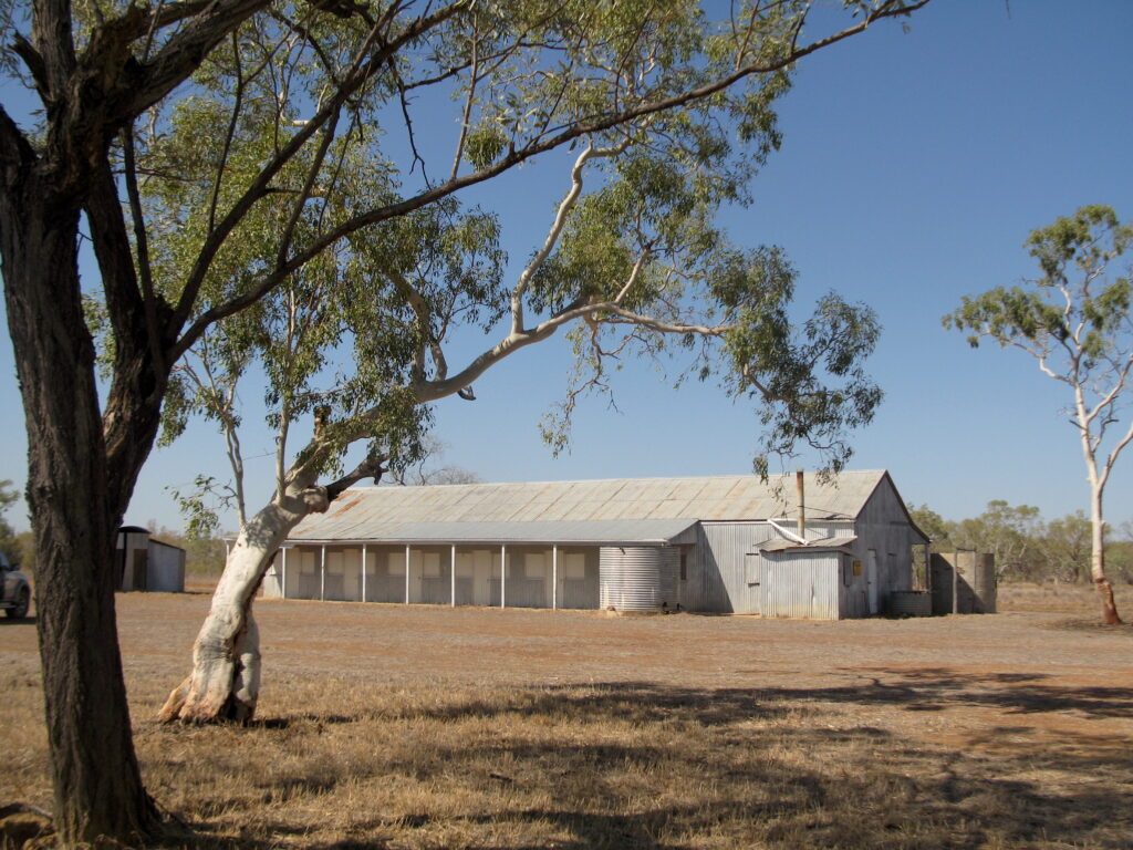
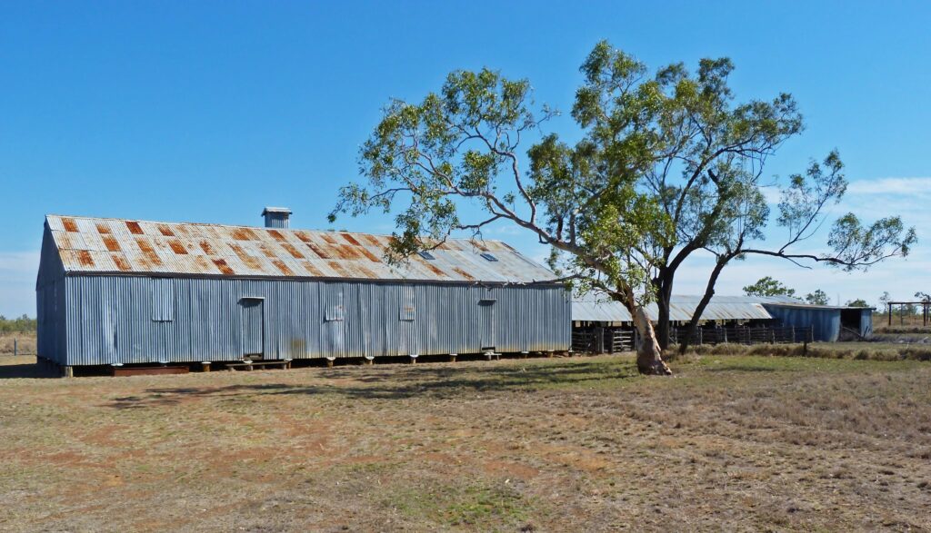
Moorrinya National Park was initially established as the sheep grazing property, Shirley Station. In the late 1970s, cattle replaced sheep and grazing continued until the park was established in 1993. Much of the sheep station infrastructure, dating back to the late 1940s, remains as a reminder of the spirit and hard work of the people who lived in this remote part of Queensland.
camping
Moorrinya National Park
Seven camp sites have been established near the old Shirley shearing shed and a composting toilet is the only facility. A camping permit is required and fees apply. A tag with your booking number must be displayed at your camp site.
Camp Site Bookings
http://www.nprsr.qld.gov.au/ or 13 QGOV (13 74 68). Bookings can also be made in person at QPWS Agents or the Flinders Discovery Centre. There is NO self registration at this camp area.
Campground features
Bush camp near an old shearing shed. Discover the farming history of the
park.
Access: the camping area can be reached by four-wheel-drive only. It is accessible for four-wheel- drive caravans, buses and camper trailers driven with care.
Number of sites: seven separate and numbered sites.
Campsites are suitable for: tent camping beside your car, camper trailers and large groups.
Campsite surface: Dirt.
Facilities: Composting toilets.
Open fires: Prohibited. Bring a gas or fuel stove.
Generators: Not permitted.
Essentials to bring: Drinking water, rubbish bags, insect repellent and a fuel stove.
Mobile phone coverage: Not available.
Location
Access to the Shirley Shearing Shed camping area is marked by directional signs. From
the entrance on the Aramac Torrens Creek Road, the track crosses Bullock Creek and travels for 6.5km through acacia and bluegrass communities. Turn right, just past the Shirley Homestead and travel 4.5km to a Y intersection. The camping area is 4.3km along the right-hand side road.
Moorrinya National Park was originally Shirley Station until 1993 when the area was declared a national park
things to do
Walking
Bullock Creek walk—200 m return (15 mins)
Grade: easy
Take this short stroll from the camping area to Bullock Creek. At the creek look for native fish including spangled perch Leiopotherapon unicolor, glassfish Ambassis sp. and silver catfish Plotosus argenteus. Waterbirds, such as the hoary-headed grebe Poliocephalus poliocephalus, Australasian darter Anhinga novaehollandiae and marsh sandpiper Tringa stagnatilis may be seen searching for food amongst the reeds. Shade is limited so try to walk in the cooler parts of the day.
Driving
Ride trail bikes and drive four-wheel-drives on Moorinya’s internal roads and firebreaks. Riders and drivers must be licensed and trail bikes and vehicles must be fully registered. Normal road rules apply and penalties will be enforced. Vehicle access is not maintained within the stock route. Expect to share the roads with pedestrians, cyclists and other vehicles.
Stay on formed roads—trail bikes and vehicles are not permitted off-road or on the walking track.
Mountain Biking
Mountain bike on Moorinya’s internal roads and firebreaks. Expect to share the roads with wildlife, pedestrians and vehicles.
Viewing wildlife
The park is popular with birdwatchers and nature lovers—165 bird, 40 reptile, 17 mammal, nine frog and seven fish species have been recorded in the park.
Red-winged parrots Aprosmictus erythropteru, pale headed rosellas Platycercus adscitus and sulphur- crested cockatoos Cacatua galerita are often seen near the camping area, especially at dawn and dusk.
During the day look for koalas Phascolarctos cinereus sleeping in the canopies of eucalypt trees, and eastern grey kangaroos Macropus giganteus, common wallaroos Macropus robustus and red kangaroos Macropus rufus seeking shade from the sun’s heat. Double-barred finches Taneiopygia bichenovii and chestnut-breasted mannikins Lonchura castaneothorax are often be seen near the ground, as are squatter pigeons Geophaps scripta, which prefer to walk unless threatened.
At night listen for the ‘woof woof’ call of barking owls Ninox connivens and maybe see a sugar glider Petaurus breviceps soaring from tree to tree. During the wet season the park becomes alive with the sounds of frog calls. Listen for the ornate burrowing frog Platyplectrum ornatum, the greenstripe frog Cyclorana alboguttata and the northern laughing treefrog Litoria rothi.
Things to know before you go
Remember to tell a responsible person where you are going and when you expect to return. Let them know your route and contact them on your safe return. Have a contingency plan in place if you fail to contact them by the agreed time. If you change your plans, inform them. A bushwalking registration form can be obtained online from the EPA website or from your local Queensland Parks and Wildlife Service office. Please be aware that QPWS will not check you have returned from your trip although the details on the form can provide important information for search authorities.
In the event of an emergency, communication equipment is vital. You should carry at least one form of communication equipment. Only Next G mobile phones may work here and because coverage is very
limited, they should not be relied upon as the only form of emergency communication. In the case of an emergency, if network coverage is available, dial 000 or 112. A sign with an emergency information list, including map coordinates, nearest police station and mobile phone coverage, is located at Canns Camp Creek campground.
Essentials to bring
∙ A first aid kit.
∙ Fresh water, as water is not provided.
∙ A fuel stove and fuel, as fires and generators are not permitted.
∙ A sealable container for rubbish. Bins are not provided at the campground. Please take your rubbish home with you.
∙ A hat, sunscreen and sunglasses. Some areas of the park are quite exposed.
Pets
Domestic animals are not permitted in White Mountains National Park.
Climate and weather
Days can be very hot between October to March, reaching an average temperature of 32 to 36 degrees Celsius. Hot summer days at times exceed 40 degrees Celsius. Wet periods occur during this time that can make access difficult to impossible. It is preferable to visit in the cooler months, from April to September, when daily temperatures average a more pleasant 28 degrees Celsius.
Staying safe
∙ Never walk alone. Small groups of four are ideal.
∙ Carry adequate drinking water. Treat water collected from creeks.
∙ Protect yourself from the sun. Wear sunscreen, a hat, sunglasses and a long-sleeved shirt, even on cloudy days.
∙ Set up camp well before dark. For your safety do not walk at night.
∙ Wear insect repellent, clothing and shoes to protect yourself from stings, scratches and bites.
Wheelchair accessibility
Burra Range lookout is wheelchair-accessible but has no safety rails at the edge. The toilet at the campground is not wheelchair-accessible.
Flinders Discovery Centre
37 Gray Street, Hughenden Q 4821
PO Box 274, Hughenden Q 4821
Ph: (07) 4741 2970
Email: info@flinders.qld.gov.au
QPWS
Disraeli Street, Hughenden Q 4821
Ph: (07) 4741 1113